Welcome to Electric-Bikes.com
Personal Rapid Transit (PRT) "ferry" over the railroad tracks in Milpitas
The Sunnyhills Neighborhood Association (SNA) is working toward the goal of a PRT feeder from their neighborhood at the North end of Milpitas to the Great Mall Transit Center (LRT, buses and future BART) at the South end 3.5 miles away. PRT is a new technology, so it makes sense to limit our risk by starting small with a minimal system of two stations and a loop connecting them. People get on at one station and ride to the other station. We could use such a system to safely "ferry" people over the railroad tracks between Yosemite Drive and Curtis Avenue near the Great Mall and LRT station. (Over the years, various City documents have called for a pedestrian/cyclist crossing at that location.) Such a demonstration system, costing less than a standard steel-and-concrete pedestrian bridge, will allow us to verify PRT technology before we decide about expanding the system to service Sunnyhills.The advantages of being the first City to implement PRT are attractive. If we're first, the Milpitas PRT will become both a regional and a national tourist attraction bringing fame, acclaim, and extra tax dollars. Being first will allow us to pay less; outside funding from groups interested in our "experimental project" will help reduce our portion of construction costs from the standard 20% to only 10% -- or even less. (It could be argued that Milpitas shouldn't pay anything because we're taking the "risk" of being first.) Being first will also put us in the lead for funding of extensions to the Library, Sunnyhills, and perhaps the BART station in Fremont. Because PRT is scalable, i.e. it works as a small or large system, we can grow the system over time as need and opportunities arise.

The Milpitas PRT "ferry" over the railroad tracks will connect Curtis Avenue with Yosemite Drive at the north end of the Great Mall. The blue dots indicate the general location of the two stations. The green dot shows the LRT station above Main Street.
A first step for any public works project is writing an Environmental Impact Report (EIR) which, for this "ferry" project, will cost about $50,000. SNA will apply for grant funding from foundations and other sources. Many foundations will want to contribute because PRT addresses environmental issues, social equity and transportation issues, and also provides a model that can be repeated in most cities in our nation.
You can help. In addition to foundation funding, SNA is inviting $5 pledges from people who are willing to back this "ferry" with $5 of their own money. After the first $45,000 in grant funding is secured, we'll return to those who pledged $5 to collect. Your pledge will demonstrate the public support which makes the grant funding part even easier. If you'd like to participate in this experiment in democracy, contact Rob Means at 408-262-0420 or rob.means@electric-bikes.com. You can also print the pledge form at
www.electric-bikes.com/prt/prt-survey-2.html
What is PRT?
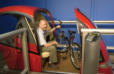
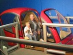
- Cabs (right) are small, light-weight, and electric powered. Each cab accomodates 1 to 3 people and travels 20-40 mph. Computer-controlled operation provides 24/7 service and safety. Click here for a 30-second video of Skyweb Express (pictured).
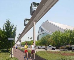
- Guideways (left), with a diameter of only 3 feet, can be routed through small spaces and even into buildings. Support posts rise every 60-90 feet from a 2 ft2 footprint.
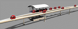
- Stations (right) are 1) small, 2) spaced about 1/2 mile apart, and 3) off the main line so cabs can proceed non-stop to their destinations. Stations may be elevated or at ground level; elevated stations include elevators. Stations include cameras for security and storage for idle cabs.
Click here for a 3-minute video introduction to PRT technology.
Photos of the Crossing Site (Click here for an aerial view.)
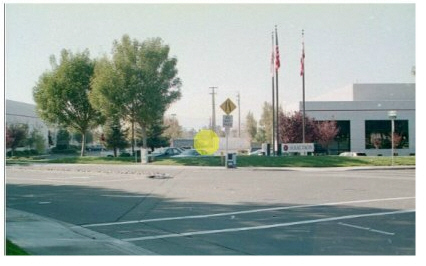
In this first photo, we are looking west along Yosemite Drive where it curves south to become Gibraltar Drive. Gibraltar Court enters from the right. The yellow circle highlights the corridor that PRT will use to cross over the tracks to Curtis Avenue. Running between buildings #3 and #4 is a City easement for underground utilities. On the far side of the tracks, telephone/utility poles line Curtis Avenue.

At the west end of the Flextronics parking lot, behind the cyclone fence, is a 30-foot wide security drive. Beyond that lies the 50-foot wide railroad right-of-way that is bordered by two cyclone fences.
The railroad right-of-way is easily spanable by a PRT guideway. Just beyond the tracks you see a white utility truck parked. The cars in the background are on Curtis Avenue.
Additional Information
- Learn more about PRT at www.electric-bikes.com/prt/prt-info.html
- Learn more about PRT's potential for Milpitas at www.electric-bikes.com/prt/prt-milp.html
- SNA's proposal for a city-wide PRT system would save transportation dollars.
- Find a draft funding proposal for this project at www.electric-bikes.com/prt/prt-grant.html
Request for support.
Help the Sunnyhills Neighborhood Association (SNA) demonstrate public support -- pledge $5 for an EIR.
SNA plans to acquire $45,000 from foundations and other sources for an Environmental Impact Report (EIR), the first step toward implementing a public works project like this. After raising the $45,000, those who pledge $5 will be contacted for their contribution. Make your pledge today for clean, energy-efficient, quick and reliable transportation.